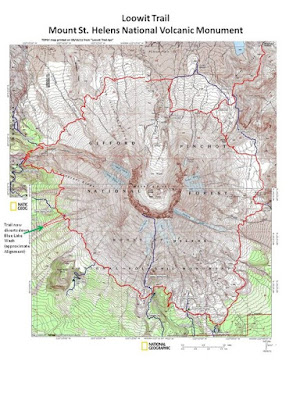
The Loowit Trail is a 50k loop around Mount St Helens that winds, climbs, and descends through incredibly rugged, diverse landscapes, gaining and losing 2300m of elevation over its course. This circumnavigation allows you to experience all the after effects of the catastrophic 1980 eruption of the volcano, and to witness the tenacity of the vegetation and wildlife that is slowly returning to the denuded environment. This past weekend, I went with three girlfriends to run this trail in one day. Organized by the incomparable Alicia, our adventure would have us camping overnight at the June Lake trailhead and striking out for the Loowit Trail at 8 a.m., carrying 2 L of water apiece, plus headlamps, clothing layers, emergency supplies, and LOTS of calories in various forms (from gels to Clif bars to Subway sandwiches to salty wasabi peas). We knew this was going to take much longer than your average 50k due to the technical and rugged nature of the terrain.

Starting at June Lake allowed us a steep but non-technical climb through the forest to start our day. After about 2 miles, we reached the junction with the Loowit Trail and were soon clambering over expansive lava fields, the route through which was marked with sporadic tall posts, small orange flags, and cairns.

Tara and Alicia ascending the rocky lava field on the southwest side of the mountain
|
This early part of the day was when we were moving the most slowly,
mostly due to the fact that we were rock-hopping along the lava beds and crossing several washed-out regions where we would need
to scramble down a steep slope into a gully and back up the other side. We
briefly lost the trail a couple times when crossing these gullies - but could
always spot it on the other side - so the only real challenge was trying to find the
best route down and up the loose scree. After about a 600m climb from our starting point, we topped out at just over 1400m elevation and were rewarded with a peek-a-boo view of Merrill Lake nestled in the rolling hills of the Cascades.
 |
| Lots of lava to navigate. View of Merrill Lake in the distance. |
We continued across the seemingly never-ending sharp rocks for about another 6 km before reaching a spectacular 360 degree viewpoint where we could see Mt Hood to the south.
 |
| Snack with a view. Mt. Hood in the far left of the picture. Photo: Tory Scholz |
At this juncture the trail starts to climb and fall through subalpine forest, travels along the ridge of the enormous Sheep Canyon, and crosses a zone of burned trees and regenerating meadows. After about 3.5 hours of climbing and navigating extremely technical terrain, it was a joy to run on this section of trail with relatively good footing and stunning views all around.
 |
| Running along the ridge of Sheep Canyon |
 |
| Meadows and burned trees |
The Loowit brought us down to the Toutle River on a fun, leafy trail that switchbacked through remnant old-growth forest, at the end of which we needed to descend to the river bed with a rope because of the steeply eroded valley walls consisting of loose rock and pumice. 22k into our day we stopped at the river to replenish our water and eat lunch.
 |
| Our lunch spot: the Toutle River |
 |
| Initial climb out of the Toutle River Valley |
Climbing out of the river valley was one of the highlights of the day for me. We had re-fuelled and had tons of energy as we scaled our way back up the valley wall and onto a steep, narrow trail that approached the northwest flank of the volcano, with the wind whipping up ash clouds all around us. This treed section gave way to a benched trail on an insanely steep, high slope where each step sunk your foot into ash. Pretty surreal.
 |
| Approaching the volcano from the northwest |
 |
| There is a trail there, I swear. |
As we finally crested the ridge we were approaching the north side of the volcano, where the full force of the 1980 eruption blew apart the mountain and completely denuded the landscape. We first passed through more burned trees, with great views of the volcano to our right, and then stopped in our tracks as we entered the "blast zone".
 |
| Cresting the ridge on the northwest side of the mountain. |
 |
| The edge of the blast zone |
The Loowit Trail is named after Loowitlatkla ("Lady of Fire"), a woman in Native American Puyallup Oral Traditions who tended a sacred fire to which people would travel from miles around to get embers for their own fires. The Traditional Story goes that Loowit, as she was known, became entangled in a love triangle in which two brothers were competing for her - this culminated in a fight where entire villages were burned and forests went up in flames. A grand chief killed all three of the lovers but felt saddened at losing them, so raised a great mountain where each of them fell. According to this Story (of which this is only one version), Loowit became Mount St. Helens, and the two brothers became Mount Hood and Mount Adams.
 |
| Looking north across the other-worldly blast zone |
 |
| Looking south across the blast zone toward "the breach" - the section of the volcano that blew apart |
Entering the blast zone, one could easily imagine how these great volcanoes inspired such Oral Traditions. Running across this landscape was like being on another planet. We traversed kilometre after kilometre of rolling, dune-like barren plains, with one stream crossing where we topped off our water supplies one last time. We took in the view of Spirit Lake, its shore littered with burned, felled trees, pushed ashore by the lake and whitewashed over time to form a ghostly looking beach. We saw a herd of at least 100 elk crossing the plains toward the lake. Borne most likely out of fatigue and waning energy, we did have a brief moment of paranoia that the elk were going to corner then trample us(!) - but unsurprisingly, this did not happen, and we continued happily on our separate ways.
 |
| Crossing the blast zone, with Spirit Lake in the background. Photo: Tara Berry |
 |
| Elk. These were the ones we thought were breaking away from the herd to corner us. Photo: Tory Scholz |
Once through the blast zone, we had to run up to a high pass on the northeast side of the mountain, which was a difficult climb at this point in the day (we had been out there for about 8.5 hours). When we reached the top the wind was unbelievably strong - we later found out that this is aptly called Windy Pass. Laughing and struggling to put our jackets on (the wind was flapping them around so much it was hard to get your arms in), we hurried down the other side onto the plains of Abraham, through which the Loowit is a lovely, gently rolling, runnable trail. At some point along this section we passed a signpost that said "June Lake Trail, 6.8 miles", and were shocked that we only had this far left in our day. It felt amazing to be running easily again, and we made good time through this section ... until we reached a series of extremely challenging, sketchy gully crossings.
 |
| Clinging. Photo: Tara Berry |
This was the toughest part of the day for me mentally because I have quite a fear of traversing steep, slippery hills that slope downward to the side - terrain like this makes me freeze up and take ridiculously careful steps while clinging to whatever I can find that seems somewhat solid. Considering I was tired, the light was on the verge of starting to fade, and there were several of these in a row ... down, up, across, down, up, across ... it became a game of mental strength to keep going. Luckily I was out there with three of the most supportive, strong women you can imagine - and we got through it together, without incident.
 |
| Looking east toward Mount Adams. Photo: Tory Scholz |
Once through these relentless gully crossings the sun was starting to set and we were treated to a spectacular view of Mount Adams to the east. We actually thought that our climbing was over at this point, but ended up needing to navigate another lava field on the southeast side of the mountain that never seemed to end. We finished the last 40 minutes or so of the route with our headlamps on, and were needless to say quite excited when we started running down through forested trails once more and finally reached the June Lake trailhead junction where we had started the day almost 11 hours earlier.
This was an amazing, rugged, beautiful, challenging adventure, and only the third time in my life I've run 50k (I use the term "run" loosely here - there was definitely a lot of hiking/scrambling/climbing/clinging as well). I have the utmost respect for Mount St Helens, and am so thankful that Loowit was there to guide us and allow us to experience her incredible landscapes firsthand, on our own power. And I am forever grateful to have wonderful, strong, adventurous women like this in my life, who, like me, think that running around a volcano is the perfect way to spend a girls' weekend.


Comments
Post a Comment