Last fall, three girlfriends and I ran around Mount St Helens on the Loowit trail - and had such an incredible experience that we promptly decided to make a volcano run an annual trip. This year's adventure took us a bit farther south in the Cascade chain of stratovolcanoes, to Mount Hood in Oregon. The route around Mount Hood follows the Timberline trail, a 40-mile (65.5k) long Forest Service trail that gains a total of 9,000 ft (2700 m) as it winds around the flanks of the mountain, through alpine meadows, across ridges, and falling and rising in and out of glacial river valleys. We researched the route beforehand and found that most people travel in a clockwise direction from Timberline Lodge - this was also the route that Tara and Alicia had done last year. Based on that experience, however, Tara suggested that this year we travel counterclockwise, in order to cover the most difficult and highest terrain earlier on in the day. This turned out to be a very wise decision (more on this shortly), and I would certainly recommend this to anyone setting out later in the season as we did.
 |
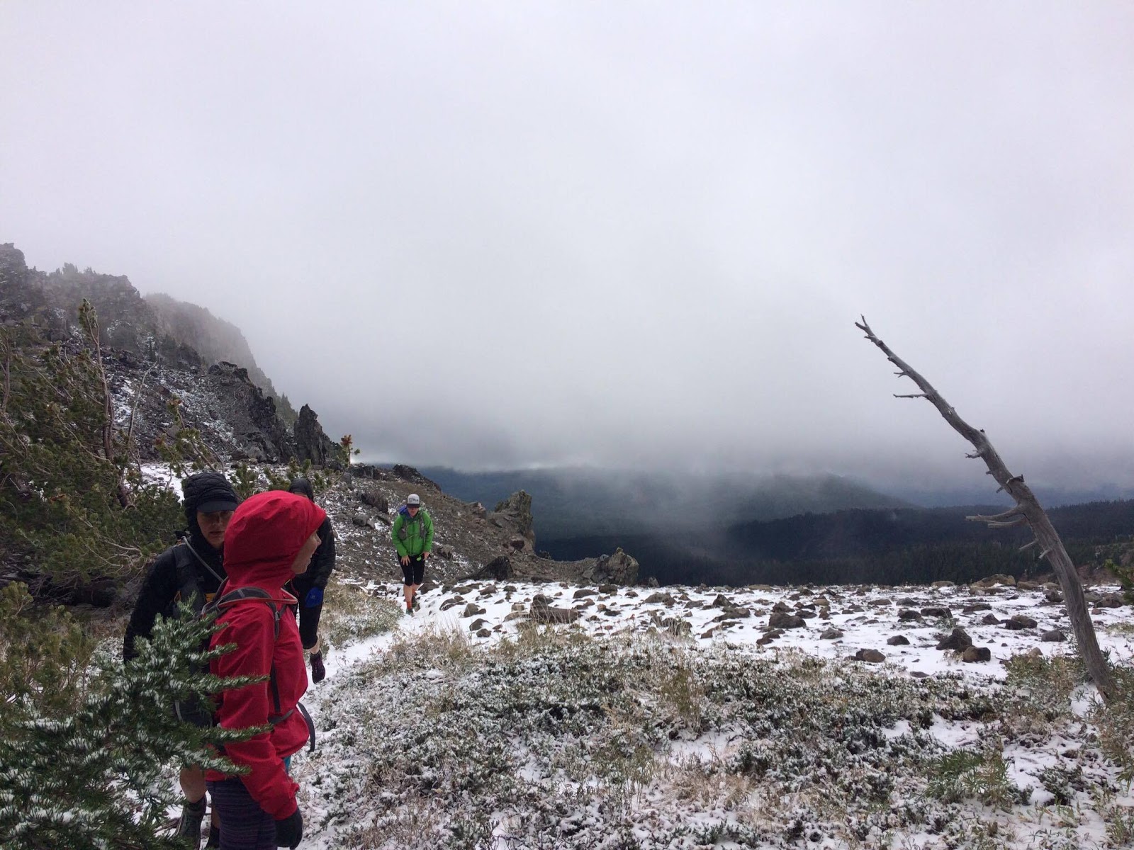
| Winter, is that you? Gnarl Ridge (yes, that's really what it's called). Photo: Tara Berry |
Our day started at 7 am from the lodge, which is situated at 4700ft (1400m) - it was snowing lightly and, based on a fickle forecast, we knew we were in for a potentially cold/snowy/rainy day. We carried the ten essentials with us, which included tons of clothing layers (including puffy jackets and Goretex shells, spare socks, gloves, and toques or buffs), basic first aid supplies, lots of calories in various forms and 2L of water apiece, a water filter and purifying tablets, matches, whistles, headlamps and emergency bivy sacks, a hard copy trail map as well as a GPS route programmed into RunGo on two separate phones, and a Spot tracker so that friends could follow our progress and know where we were located at all times. Yes, our packs were stuffed, and quite heavy - but Timberline is a wilderness route not to be taken lightly, and we felt confident that we were well prepared for the journey.
 |
A long journey: Our objective for the day. Timberline Lodge is on the south side of Mount Hood.
Source: turns-all-year.com |
I wasn't sure how my body would feel after having just run a hard mountain 54k race the week before, but as we started running my legs felt great and my mind was excited for a day of adventuring with friends. Setting out to the east from the lodge, we started across barren pumice slopes and then dropped down into a small canyon before eventually running along Boy Scout ridge with a view of White River Canyon. The early running was quite cruisy, on smooth trail through alpine scrub with periodic views of gorgeous waterfalls. On a clear day the panorama from the ridge would have been incredible, but the scenery in our immediate environment was so beautiful that we weren't missing the sweeping views. A good lesson in appreciating what you have, in the moment!
 |
| Setting out from Timberline Lodge |
Timberline switchbacks down to the White River, which was our first major glacial river crossing of the day. Chloe is skilled at picking good routes across streams as well as finding the best footing to do so, and we quickly fell into a fairly smooth routine of her guiding the rest of us across each crossing. The only issues we had with crossings all day was difficulty finding the trail once we were on the other side; trails were marked with cairns, but often there were cairns leading to campsites as well, instead of back to the Timberline trail.
 |
| Crossing the White River |
Once we located the trail, we were treated to a long, steep climb on forested switchbacks to reach Mount Hood Meadows, bursting with beautiful alpine fall colours. The sun even made a brief appearance, and spirits were high as we made our way through the meadows and down and up several more river valleys, including Clark and Newton creeks, fed by the Newton Clark glacier. OregonHikers.org refers to these creeks as "a silly torrent" and "the most unruly of Hood's glacial streams", respectively, but we made the crossings without incident. As we climbed our way out of Newton Creek Canyon about 4 hours into our run, we were heading toward its northern rim, which was to be the highest point of our day on Gnarl Ridge.
 |
| Emily making her way through Mount Hood Meadows |
Gnarl ridge is named for the twisted, ancient whitebark pines that grow in this harsh, exposed environment - but on our journey, the name was also quite appropriate to the conditions we experienced there. Being the highest elevation (about 6800 ft/2000m) that Timberline travels through, and very exposed, as soon as we crested the ridge we were greeted with swirling, pelting snow pellets and high winds that actually blew me off my course with each step. We pushed our way toward a tiny copse of trees and were amazingly sheltered behind them (thanks, gnarly pines!), and quickly stopped to put on extra layers - at this point I was wearing pretty much everything I had brought, including a long sleeved Merino wool shirt, a puffy jacket, a shell, and my toque and gloves. We discussed our concern that if these conditions persisted, it may not be safe to continue and we should probably turn around, but Tara knew that this was where we were topping out and that we would soon be descending the other side of the ridge, so we decided to keep moving forward and take stock a little further on. Sure enough, once we were on the other side of the ridge we slowly moved out of the snow and wind, and never saw those conditions again for the rest of the day. This cemented in our minds that our counter-clockwise route was the best decision, at least on that day - navigating that terrain near the end of our run when we were exhausted and wet would have been quite dangerous.
 |
| All the layers, and a gnarled Whitebark Pine. Photo: Tara Berry |
Running down from the ridge took us through a forest before reaching a loose, rocky section that gives way into an expansive boulder field with a couple short snow traverses. Timberline here travels high on the shoulder of Cooper Spur, and we cruised our way down this section, now sheltered from the wind and losing elevation as we approached the Cloud Cap campground. A rainbow appeared in the distance, as if to reassure us that everything was going to be ok, and we ended up chasing this rainbow around the mountain for the next several hours. We crested Ghost Ridge, and started picking our way down a trail toward the Eliot glacier basin crossing.
 |
| Ghost Ridge, overlooking Eliot basin. There's a glacier somewhere in that fog. |
Everything that we had read before the run had warned us about how difficult this crossing would be, due to a 2006 debris flow that had washed out the trail and left steep canyon walls full of loose rock. It sounds like the trail that we followed had just recently been completed as a detour from the original washed out route, and we had no problems at all with the crossing. The climb up the other side of the canyon was a steep scramble and there were definitely some loose rocks, but we all made it up smoothly despite a couple of us (myself included) having a fear of heights. I have realized that my fear has diminished quite a lot since the Mount St Helens run last year - this section didn't bother me at all, and I know that it would have a year ago. The more adventure runs I do like this; the further I incrementally push myself outside my comfort zone, the more confident I become. It's encouraging, and exciting.
 |
Climbing out of Eliot basin. You can see the trail we came down on the other side at the top of the picture.
Photo: Chloe Gendron |
Now on the rugged north side of Mount Hood, we ran through the remnants of the Dollar Lake fire, a massive wildfire caused by a lightning strike in 2011 that burned for 2 months and eventually consumed over 6000 acres of high elevation forest. This part of the run was a highlight for me - the burned out forest was so eerily beautiful, and offered some of the best vistas we had seen so far. Despite having been decimated by the fire, this landscape was teeming with new growth among the burned white trees. As with the vegetation that is slowly returning to the flanks of Mount St Helens after the 1980 eruption, so too will this landscape recover. It was really quite magical to be running through it.
 |
| On the edge of the burn. Still chasing that rainbow |
Mount Hood is known to the Multnomah tribe as Wy'east, and like Mount St Helens is prominent in the mythology of the region. In one legend, Wy'east was one of two sons of the Great Spirit Sahale who became entangled in a love triangle over the beautiful maiden Loowit. In their battle over her, the brothers burned forests and villages before Sahale became enraged, killed them all and then, in his grief, erected mountain peaks in honour of the star-crossed lovers. Loowit became Mount St Helens and Wy'east, being the proudest of the brothers, became the tall and imposing Mount Hood. Making the full journey around these volcanoes demands a great respect for their wildness, and seems like a fitting way to honour these indigenous legends. If it was easy, the journey would not be as meaningful. More than 8 hours into our day at this point, we were all growing tired - but we continued to move forward. Every time I started to falter, I reminded myself how lucky I was to be able to do something like this, and took a moment to look around and take it all in: Beautiful landscapes. Incredible single track trail. A volcano. A rainbow. Strong, inspiring, supportive women (otherwise known as unicorns). A recipe for an amazing experience.
 |
| Partly burned out, but still thriving. A good metaphor for this point in the day. |
As we made our way around the western side of the mountain, we moved in and out of more meadows, river crossings, and steep switchback sections of trail. We had one unfortunate incident where we got a bit carried away running down a fun series of switchbacks for a few kilometres - before realizing that we were heading in the wrong direction, and having to turn around and climb back up until we regained the Timberline trail. We also followed a sign at one trail junction that said "PCT to Timberline Lodge" - we knew that Timberline coincided with the PCT for several miles near the end of our day, so thought this was correct, but soon realized that we were headed on a wider loop out to the west than we had been expecting. Right general direction, just a few "bonus miles" (!). These were our only two mistakes of the day, though, and neither set us back very far. We got back on our intended course and started running down an incredibly long, fun section of somewhat technical forested trail (which was a bit worrisome at this point in the day, because we knew Timberline Lodge was at quite a high elevation - which meant we would eventually be climbing back up again). Just as the daylight was starting to fade, we wound our way down into the massive Zigzag canyon and up the other side. And, sure enough, this is where the climbing started again...and never seemed to end.
 |
| Zigzag Canyon. Photo: Tory Scholz |
As we ascended switchback after switchback, we were slowed to a hike and my energy started to plummet. My muscles felt fine, but I was just so exhausted that I really started to struggle at this point. I think it was a combination of leftover fatigue from the race the week before, and not eating enough toward the end of the day. Reduced to silence except for the odd involuntary grunting/whimpering sounds that I was making as I trudged upward, I kept putting one foot in front of the other, and tried to stay positive. Huge shout out here to Tory, who saw what was happening and tried to distract me with stories, and Emily, who said simply at one point "right now I'm just grateful that it's not raining". We were all experiencing our own levels of low points at this stage, and yet we got each other through it. This is what I love about days like this, and about sharing these adventures with like-minded, supportive friends. I think that you need those low points to make the experience rich; they let you know what you are capable of, and just how much your mind can get your body through. It's like those burned out sections of trail: nature is tenacious, and so are we. In everyday life, we just don't get enough opportunities to find out how strong we really are.

We finally crested the last climb, and started to see the lights from the lodge in the distance. We spent the last 1-1.5 hours of our day in darkness, guided by the light of our headlamps. When we got to a sign that said "Timberline Lodge, 1 mile", I thought I was going to cry in happiness. Emily and I looked at each other and said in unison, "We can run a mile" - and so we did.
68 km, 3400 m of climbing, and 13+ hours after we set out from Timberline Lodge that morning, we burst through its doors to some surprised glances from patrons - muddy, wet, and grinning from ear to ear. All of the hardships of the last few hours slowly melted away as we changed into warm dry clothes, drank local craft beer, and swapped stories and laughs. What a day. Thank you, Wy'east, for welcoming a group of unicorns to honour you with our annual journey.


nice write-up. love the photos, such colours!
ReplyDelete